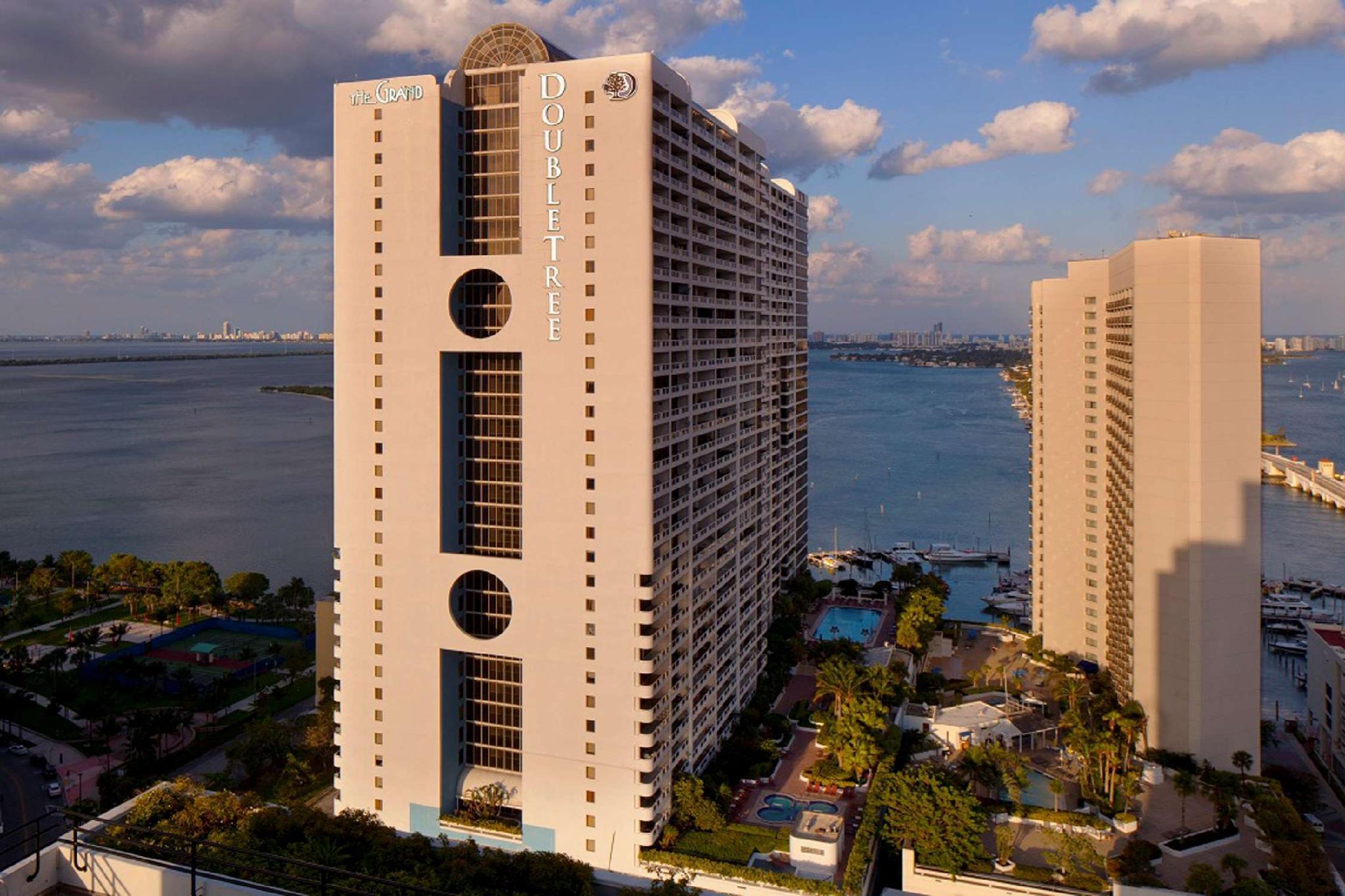
There are 4 ways to get from Mac-Ivor & Friends Airstrip to Doubletree Grand Hotel Biscayne Bay by train, bus,rideshare, car or plane
Driving
Total time spent: 40 mins
Distance:0.2 mi
Duration:1 min
Head east on SW 59th Ct toward SW 166th Ave
Distance:315 ft
Duration:1 min
Turn right onto SW 166th Ave
Distance:0.5 mi
Duration:1 min
Turn left at the 1st cross street onto Stirling Rd
Distance:1.0 mi
Duration:2 mins
Turn right onto SW 160th Ave/
Distance:0.3 mi
Duration:1 min
Turn left onto FL-822/
Distance:10.5 mi
Duration:10 mins
Slight right to merge onto I-75 S toward Miami
Distance:8.1 mi
Duration:9 mins
Take exit 1B to merge onto FL-826 S toward Int'l Airport/
Distance:0.1 mi
Duration:1 min
Take the 836 exit
Distance:7.6 mi
Duration:9 mins
Keep left at the fork, follow signs for FL-836 E/
Distance:0.9 mi
Duration:1 min
Continue onto FL-836 E/
Distance:79 ft
Duration:1 min
Continue onto MacArthur Cswy
Distance:0.3 mi
Duration:1 min
Take exit 2A on the left for NE 2nd Ave toward US-1/
Distance:0.3 mi
Duration:2 mins
Turn left onto NE 2nd Ave
Distance:0.2 mi
Duration:2 mins
Turn right onto NE 15th St
Distance:0.1 mi
Duration:1 min
Turn left onto N Bayshore Dr
Walking
Total time spent: 9 hours 19 mins
Distance:0.2 mi
Duration:5 mins
Head east on SW 59th Ct toward SW 166th Ave
Distance:315 ft
Duration:1 min
Turn right onto SW 166th Ave
Distance:3.5 mi
Duration:1 hour 11 mins
Turn left onto Stirling Rd
Distance:1.0 mi
Duration:21 mins
Turn right
Distance:36 ft
Duration:1 min
Turn left
Distance:0.1 mi
Duration:3 mins
Turn left
Distance:0.1 mi
Duration:2 mins
Turn right toward NW 120th Terrace
Distance:223 ft
Duration:1 min
Turn right onto NW 120th Terrace
Distance:0.2 mi
Duration:3 mins
NW 120th Terrace turns left and becomes NW 23rd St
Distance:0.3 mi
Duration:6 mins
Turn right onto NW 118th Ave
Distance:0.4 mi
Duration:8 mins
Turn left onto Taft St
Distance:0.6 mi
Duration:13 mins
Turn right onto N Hiatus Rd
Distance:0.3 mi
Duration:6 mins
Turn left onto Johnson St
Distance:0.5 mi
Duration:9 mins
Turn right onto NW 108th Ave
Distance:1.5 mi
Duration:31 mins
Turn left onto Pines Blvd
Distance:0.2 mi
Duration:3 mins
Turn right
Distance:0.3 mi
Duration:6 mins
Turn right onto SW 89th Ave/
Distance:39 ft
Duration:1 min
Turn left toward SW 89th Ave/
Distance:5.3 mi
Duration:1 hour 47 mins
Turn right onto SW 89th Ave/
Distance:1.1 mi
Duration:21 mins
Turn left onto NW 37th Ave/
Distance:0.1 mi
Duration:2 mins
Turn left onto NW 151st St/
Distance:0.8 mi
Duration:15 mins
Turn right onto Perviz Ave
Distance:285 ft
Duration:1 min
Turn left toward Opa-locka Blvd
Distance:0.4 mi
Duration:8 mins
Turn right onto Opa-locka Blvd
Distance:0.1 mi
Duration:3 mins
Turn left onto York St
Distance:226 ft
Duration:1 min
Turn right toward Superior St
Distance:0.3 mi
Duration:6 mins
Slight left onto Superior St
Distance:0.1 mi
Duration:2 mins
Turn right onto NW 24th Ave
Distance:0.3 mi
Duration:5 mins
Turn left onto NW 136th St/
Distance:1.8 mi
Duration:36 mins
Turn right onto NW 22nd Ave
Distance:0.5 mi
Duration:10 mins
Turn left onto NW 107th St
Distance:0.4 mi
Duration:9 mins
Turn right onto NW 17th Ave
Distance:0.4 mi
Duration:8 mins
Turn left onto Little River Dr
Distance:200 ft
Duration:1 min
Turn left onto NW 95th St
Distance:184 ft
Duration:1 min
Sharp right to stay on NW 95th St
Distance:1.0 mi
Duration:20 mins
Turn left onto Little River Dr
Distance:2.6 mi
Duration:53 mins
Turn right onto NW 7th Ave
Distance:0.1 mi
Duration:3 mins
Turn left onto NW 46th St
Distance:0.4 mi
Duration:8 mins
Turn right onto NW 6th Ave
Distance:0.3 mi
Duration:5 mins
Continue onto NW 40th St
Distance:0.7 mi
Duration:14 mins
Turn right onto NW 2nd Ave
Distance:0.4 mi
Duration:8 mins
Turn left onto NW 29th St
Distance:0.2 mi
Duration:5 mins
Slight right onto NE 29th St
Distance:0.8 mi
Duration:17 mins
Turn right onto Biscayne Blvd
Distance:0.1 mi
Duration:2 mins
Turn left onto NE 17th Terrace
Distance:292 ft
Duration:1 min
Continue straight onto N Bayshore Dr
Bicycling
Total time spent: 2 hours 37 mins
Distance:0.2 mi
Duration:1 min
Head east on SW 59th Ct toward SW 166th Ave
Distance:351 ft
Duration:1 min
Turn right onto SW 166th Ave
Distance:0.5 mi
Duration:2 mins
Turn left onto Stirling Rd
Distance:1.5 mi
Duration:8 mins
Turn right onto SW 160th Ave/
Distance:0.3 mi
Duration:2 mins
Turn left onto NW 15th St
Distance:0.5 mi
Duration:2 mins
Continue onto NW 155th Ave
Distance:0.8 mi
Duration:4 mins
Turn left to stay on NW 155th Ave
Distance:2.4 mi
Duration:12 mins
Turn left onto Pines Blvd
Distance:1.0 mi
Duration:5 mins
Turn right onto FL-823 S/
Distance:2.0 mi
Duration:10 mins
Turn left onto Pembroke Rd
Distance:1.6 mi
Duration:9 mins
Turn right onto Palm Ave
Distance:3.2 mi
Duration:17 mins
Continue onto State Hwy 847/
Distance:2.5 mi
Duration:14 mins
Turn left onto NW 167th St/
Distance:3.5 mi
Duration:21 mins
Turn right onto NW 22nd Ave
Distance:1.0 mi
Duration:5 mins
Turn left onto NW 111th St
Distance:0.8 mi
Duration:4 mins
Turn right onto NW 12th Ave
Distance:0.4 mi
Duration:2 mins
Turn left onto NW 99th St
Distance:0.7 mi
Duration:4 mins
Turn right onto NW 8th Ave
Distance:0.1 mi
Duration:1 min
Turn left onto Little River Dr
Distance:0.7 mi
Duration:4 mins
Turn right onto NW 7th Ave
Distance:331 ft
Duration:1 min
Turn left onto NW 77th St
Distance:0.1 mi
Duration:1 min
Turn right onto NW 6th Ct
Distance:0.4 mi
Duration:2 mins
Turn left onto NW 75th St
Distance:3.3 mi
Duration:19 mins
Turn right onto NW 2nd Ave
Distance:0.5 mi
Duration:3 mins
Turn left onto NW 20th St
Distance:0.2 mi
Duration:1 min
Turn right onto NE 2nd Ave
Distance:0.2 mi
Duration:2 mins
Turn left onto NE 17th Terrace
Distance:335 ft
Duration:1 min
Continue onto N Bayshore Dr
Distance:118 ft
Duration:1 min
Make a U-turn
Transit
Total time spent: 2 hours 43 mins
Distance:0.8 mi
Duration:16 mins
Walk to SW 160 Av & Stirling Rd
Distance:8.2 mi
Duration:31 mins
Bus towards Pembroke Lakes Mall Via Hospital & Academic Village
Distance:0.5 mi
Duration:11 mins
Walk to Pines Blvd & Flamingo Rd
Distance:25.3 mi
Duration:1 hour 11 mins
Bus towards Express Brickell Via Miramar P&R & Downtown Miami
Distance:161 ft
Duration:1 min
Walk to Government Center Station
Distance:2.4 mi
Duration:10 mins
Light rail towards School Board
Distance:0.2 mi
Duration:3 mins
Walk to 1717 N Bayshore Dr, Miami, FL 33132, USA
Questions & Answers
The cheapest way to get from Mac-Ivor & Friends Airstrip to Doubletree Grand Hotel Biscayne Bay is to walking which costs $0 and takes 9 hours 19 mins.
The fastest way to get from Mac-Ivor & Friends Airstrip to Doubletree Grand Hotel Biscayne Bay is to driving. Taking this option will takes 40 mins.
No,there is no direct bus departing from Mac-Ivor & Friends Airstrip to Doubletree Grand Hotel Biscayne Bay,you may have to walk for a while.The journey takes approximately 2 hours 43 mins.
No, there is no direct train departing from Mac-Ivor & Friends Airstrip to Doubletree Grand Hotel Biscayne Bay. you may have to driving,this way will takes 40 mins.
The road distance between Mac-Ivor & Friends Airstrip to Doubletree Grand Hotel Biscayne Bay is 30.2 mi.
The best way to get from Mac-Ivor & Friends Airstrip to Doubletree Grand Hotel Biscayne Bay without a car is to bicycling which takes 2 hours 37 mins.
The driving from Mac-Ivor & Friends Airstrip to Doubletree Grand Hotel Biscayne Bay takes 40 mins.
Mac-Ivor & Friends Airstrip to Doubletree Grand Hotel Biscayne Bay bus services, depart from SW 160 Av & Stirling Rd station.
You can drive from Mac-Ivor & Friends Airstrip to Doubletree Grand Hotel Biscayne Bay,which takes 40 mins.
The best way to get from Mac-Ivor & Friends Airstrip to Doubletree Grand Hotel Biscayne Bay is to driving which takes 40 mins.