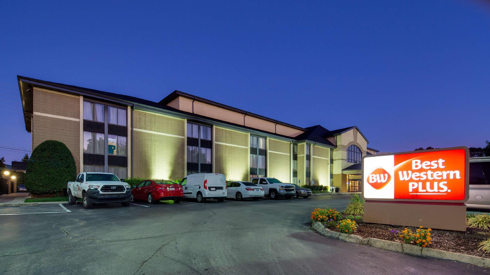


There are 3 ways to get from Moore Murrell Airport to Best Western Plus Knoxville Cedar Bluff by train, bus,rideshare, car or plane
Driving
Total time spent: 58 mins
Distance:299 ft
Duration:1 min
Head northwest toward Old Hwy 11E
Distance:0.8 mi
Duration:2 mins
Turn left onto Old Hwy 11E
Distance:0.2 mi
Duration:1 min
Turn right onto Air Park Blvd
Distance:28.4 mi
Duration:36 mins
Turn left onto US-11E
Distance:15.5 mi
Duration:14 mins
Merge onto I-40 W/
Distance:0.4 mi
Duration:1 min
Take exit 378A-B for Cedar Bluff Rd
Distance:0.4 mi
Duration:1 min
Keep left to continue on Exit 378A, follow signs for Cedar Bluff Rd S
Distance:0.2 mi
Duration:1 min
Turn left onto N Cedar Bluff Rd
Distance:0.7 mi
Duration:2 mins
Turn right after Chipotle Mexican Grill (on the right)
Distance:184 ft
Duration:1 min
Turn right to stay on N Peters Rd
Distance:230 ft
Duration:1 min
Turn left
Walking
Total time spent: 15 hours 39 mins
Distance:299 ft
Duration:1 min
Head northwest toward Old Hwy 11E
Distance:0.8 mi
Duration:16 mins
Turn left onto Old Hwy 11E
Distance:0.3 mi
Duration:6 mins
Turn right onto Air Park Blvd
Distance:3.3 mi
Duration:1 hour 3 mins
Turn left onto US-11E
Distance:5.5 mi
Duration:1 hour 49 mins
Turn right onto E Old A J Hwy/
Distance:20.6 mi
Duration:6 hours 39 mins
Turn right onto US-11E S
Distance:4.8 mi
Duration:1 hour 38 mins
Slight left onto US-11E N/
Distance:0.6 mi
Duration:12 mins
Continue onto W Fifth Ave
Distance:0.5 mi
Duration:9 mins
Turn left onto University Ave
Distance:272 ft
Duration:1 min
Slight left to stay on University Ave
Distance:1.6 mi
Duration:32 mins
Continue onto Middlebrook Pike
Distance:404 ft
Duration:2 mins
Turn left onto Liberty St/
Distance:1.6 mi
Duration:33 mins
Turn right onto Papermill Dr NW
Distance:0.3 mi
Duration:6 mins
Slight right to stay on Papermill Dr NW
Distance:1.6 mi
Duration:33 mins
Slight right to stay on Papermill Dr NW
Distance:1.6 mi
Duration:34 mins
Turn right onto Kingston Pike
Distance:0.3 mi
Duration:7 mins
Turn right onto N Winston Rd
Distance:0.4 mi
Duration:7 mins
Turn left onto Jean Teague Greenway/
Distance:0.1 mi
Duration:2 mins
Turn left to stay on Jean Teague Greenway/
Distance:0.2 mi
Duration:4 mins
Turn right onto E Walker Springs Ln
Distance:105 ft
Duration:1 min
Turn right
Distance:466 ft
Duration:2 mins
Turn left toward North Gallaher View Rd NW
Distance:135 ft
Duration:1 min
Turn left toward North Gallaher View Rd NW
Distance:381 ft
Duration:2 mins
Turn left onto North Gallaher View Rd NW
Distance:0.2 mi
Duration:4 mins
Turn right
Distance:95 ft
Duration:1 min
Turn left toward Walbrook Dr
Distance:0.5 mi
Duration:10 mins
Turn right onto Walbrook Dr
Distance:0.2 mi
Duration:4 mins
Turn right onto Bridgewater Rd
Distance:0.6 mi
Duration:11 mins
Turn left onto Knoxville City Greenways/
Distance:0.1 mi
Duration:3 mins
Slight left
Distance:476 ft
Duration:2 mins
Turn left
Distance:0.1 mi
Duration:2 mins
Turn right
Distance:285 ft
Duration:1 min
Turn left toward N Peters Rd
Distance:1.0 mi
Duration:21 mins
Turn right onto N Peters Rd
Distance:184 ft
Duration:1 min
Turn right to stay on N Peters Rd
Distance:230 ft
Duration:1 min
Turn left
Bicycling
Total time spent: 4 hours 28 mins
Distance:335 ft
Duration:1 min
Head west toward Old Hwy 11E
Distance:0.8 mi
Duration:5 mins
Turn left onto Old Hwy 11E
Distance:0.3 mi
Duration:3 mins
Turn left onto Air Park Blvd
Distance:1.0 mi
Duration:4 mins
Turn right onto Commerce Blvd
Distance:1.2 mi
Duration:5 mins
Turn left onto Hunter St
Distance:187 ft
Duration:1 min
Turn right onto TN-341 W
Distance:0.4 mi
Duration:2 mins
Turn left onto Natchez Rd
Distance:0.4 mi
Duration:3 mins
Turn right onto Mayfield Dr
Distance:302 ft
Duration:1 min
Turn right to stay on Mayfield Dr
Distance:0.1 mi
Duration:2 mins
Turn left onto US-11E S
Distance:0.8 mi
Duration:3 mins
Turn right onto E Old A J Hwy/
Distance:3.1 mi
Duration:15 mins
Turn right to stay on E Old A J Hwy/
Distance:0.7 mi
Duration:4 mins
Turn right onto E Main St
Distance:161 ft
Duration:1 min
Turn left onto Short Ave
Distance:1.6 mi
Duration:11 mins
Turn right onto W Old Andrew Johnson Hwy
Distance:3.4 mi
Duration:15 mins
Slight left onto TN-92 S/
Distance:371 ft
Duration:1 min
Turn right onto Nance Rd
Distance:0.2 mi
Duration:1 min
Slight left onto Ravine Ln
Distance:0.2 mi
Duration:1 min
Slight right onto W Old A J Hwy/
Distance:3.5 mi
Duration:16 mins
Slight left to stay on W Old A J Hwy/
Distance:0.2 mi
Duration:1 min
Turn right onto Hodges Switch Rd
Distance:1.1 mi
Duration:5 mins
Turn left to stay on Hodges Switch Rd
Distance:2.3 mi
Duration:11 mins
Continue onto W Old A J Hwy/
Distance:1.4 mi
Duration:7 mins
Slight right onto US-11E S
Distance:0.4 mi
Duration:4 mins
Turn left onto Strawberry Plains Pike
Distance:0.2 mi
Duration:1 min
Turn right onto N Ruggles Ferry Pike
Distance:194 ft
Duration:1 min
Turn left onto US-11E S
Distance:5.7 mi
Duration:28 mins
Turn right onto N Ruggles Ferry Pike
Distance:184 ft
Duration:1 min
Keep left to stay on N Ruggles Ferry Pike
Distance:6.5 mi
Duration:34 mins
Turn right onto US-11E S/
Distance:0.2 mi
Duration:1 min
Turn left onto Winona St
Distance:0.2 mi
Duration:1 min
Turn right onto McCalla Ave
Distance:0.7 mi
Duration:4 mins
Continue onto E Jackson Ave
Distance:0.4 mi
Duration:3 mins
Turn left onto S Gay St
Distance:1.4 mi
Duration:9 mins
Turn right onto Clinch Ave
Distance:0.1 mi
Duration:1 min
Turn left onto 22nd St
Distance:351 ft
Duration:1 min
Slight right onto Cumberland Ave
Distance:285 ft
Duration:1 min
Continue onto Kingston Pike
Distance:358 ft
Duration:1 min
Turn right onto Tyson McGhee Park St SW
Distance:52 ft
Duration:1 min
Turn left onto Knoxville City Greenways
Distance:0.5 mi
Duration:2 mins
Turn right onto Knoxville City Greenways/
Distance:0.1 mi
Duration:1 min
Slight left to stay on Knoxville City Greenways/
Distance:1.1 mi
Duration:5 mins
Slight left to stay on Knoxville City Greenways/
Distance:0.6 mi
Duration:3 mins
Turn left to stay on Knoxville City Greenways/
Distance:0.4 mi
Duration:2 mins
Slight left onto Third Creek Greenway
Distance:0.2 mi
Duration:1 min
Turn left onto Knoxville City Greenways/
Distance:0.2 mi
Duration:1 min
Turn right onto Third Creek Greenway
Distance:0.8 mi
Duration:4 mins
Turn left onto Bearden Village Greenway/
Distance:0.2 mi
Duration:2 mins
Slight right onto Bearden Village Greenway/
Distance:0.3 mi
Duration:2 mins
Turn right onto Kingston Pike
Distance:0.5 mi
Duration:3 mins
Turn right onto Old Weisgarber Rd/
Distance:0.5 mi
Duration:4 mins
Turn left onto Papermill Dr NW
Distance:75 ft
Duration:1 min
Turn right
Distance:384 ft
Duration:1 min
Turn left
Distance:33 ft
Duration:1 min
Turn right
Distance:0.1 mi
Duration:1 min
Turn left
Distance:0.1 mi
Duration:1 min
Turn right onto Kingston Pike
Distance:0.3 mi
Duration:2 mins
Turn right onto Wesley Rd SW
Distance:1.0 mi
Duration:7 mins
Turn left onto Sheffield Dr
Distance:0.5 mi
Duration:2 mins
Turn left onto Jean Teague Greenway/
Distance:0.4 mi
Duration:2 mins
Turn right to stay on Jean Teague Greenway/
Distance:0.1 mi
Duration:1 min
Turn left to stay on Jean Teague Greenway/
Distance:0.3 mi
Duration:1 min
Turn right onto E Walker Springs Ln
Distance:0.2 mi
Duration:1 min
Turn right onto North Gallaher View Rd NW
Distance:121 ft
Duration:1 min
Turn left toward Knoxville City Greenways/
Distance:0.5 mi
Duration:3 mins
Turn left onto Knoxville City Greenways/
Distance:0.2 mi
Duration:1 min
Turn right to stay on Knoxville City Greenways/
Distance:0.3 mi
Duration:1 min
Turn left to stay on Knoxville City Greenways/
Distance:0.6 mi
Duration:3 mins
Turn left to stay on Knoxville City Greenways/
Distance:0.1 mi
Duration:1 min
Slight left
Distance:476 ft
Duration:1 min
Turn left
Distance:0.1 mi
Duration:1 min
Turn right
Distance:121 ft
Duration:1 min
Turn left toward N Peters Rd
Distance:174 ft
Duration:1 min
Turn right toward N Peters Rd
Distance:115 ft
Duration:1 min
Turn left toward N Peters Rd
Distance:0.7 mi
Duration:5 mins
Turn right onto N Peters Rd
Distance:56 ft
Duration:1 min
Turn right
Distance:371 ft
Duration:1 min
Turn left
Distance:0.1 mi
Duration:1 min
Turn right
Distance:0.1 mi
Duration:1 min
Turn right toward N Peters Rd
Distance:102 ft
Duration:1 min
Turn left onto N Peters Rd
Distance:230 ft
Duration:1 min
Turn right
Questions & Answers
The cheapest way to get from Moore Murrell Airport to Best Western Plus Knoxville Cedar Bluff is to walking which costs $0 and takes 15 hours 39 mins.
The fastest way to get from Moore Murrell Airport to Best Western Plus Knoxville Cedar Bluff is to driving. Taking this option will takes 58 mins.
No,there is no direct bus departing from Moore Murrell Airport to Best Western Plus Knoxville Cedar Bluff,you may have to walk for a while.The journey takes approximately .
No, there is no direct train departing from Moore Murrell Airport to Best Western Plus Knoxville Cedar Bluff. you may have to driving,this way will takes 58 mins.
The road distance between Moore Murrell Airport to Best Western Plus Knoxville Cedar Bluff is 46.7 mi.
The best way to get from Moore Murrell Airport to Best Western Plus Knoxville Cedar Bluff without a car is to bicycling which takes 4 hours 28 mins.
The driving from Moore Murrell Airport to Best Western Plus Knoxville Cedar Bluff takes 58 mins.
No, there is no bus from Moore Murrell Airport to Best Western Plus Knoxville Cedar Bluff.
You can drive from Moore Murrell Airport to Best Western Plus Knoxville Cedar Bluff,which takes 58 mins.
The best way to get from Moore Murrell Airport to Best Western Plus Knoxville Cedar Bluff is to driving which takes 58 mins.